

A Python Tkinter based Inventory managment System
Introduction Inventory managemrnt system is an open source platform for manage business. It has a comprehensive, flexible ecosystem of tools, libraries, and community resources that lets businesses push to manage their system most effectively. This is a software for practice of developing a system from completely scratch. Understanding this will help a lot in system development and basic structure of a system along with GUI with python library Tkinter. This software was originally developed by Amit Kumar Datta This project […]
Read more
TkVideoplayer : a simple library to play video files in tkinter
This is a simple library to play video files in tkinter. This library also provides the ability to play , pause, skip and seek specific frames. Example: import tkinter as tk from tkVideoPlayer import TkinterVideo root = tk.Tk() videoplayer = TkinterVideo(master=root, scaled=True, pre_load=False) videoplayer.load(r”samplevideo.mp4″) videoplayer.pack(expand=True, fill=”both”) videoplayer.play() # play the video root.mainloop() read the documentation here
Read more
Unofficial PyTorch implementation of SimCLR by Google Brain
Unofficial PyTorch implementation of SimCLR by Google Brain [abs, pdf] Installation You can install the package via pip: pip install simclr_pytorch Usage You can use the SimCLR model like so: from simclr_pytorch import SimCLR train_loader = … bigcnn = ResNet50(…) simclr = SimCLR( image_size=(32, 32), bigcnn=bigcnn ) trained_bigcnn = simclr.fit(train_loader)
Read more
LayoutTransformer: Layout Generation and Completion with Self-attention
arXiv | BibTeX | Project Page This repo contains code for single GPU training of LayoutTransformer from LayoutTransformer: Layout Generation and Completion with Self-attention. This code was rewritten from scratch using a cleaner GPT codebase. Some of the details such as training hyperparameters might differ from the arxiv version of the paper. How To Use This Code Start a new conda environment conda env create -f environment.yml conda activate layout or update an existing environment conda env
Read more
Solutions of Reinforcement Learning 2nd Edition
How to contribute and current situation (9/11/2021~) I have been working as a full-time AI engineer and barely have free time to manage this project any more. I want to make a simple guidance of how to response to contributions: For exercises that have no answer yet, (for example, chapter 12) Prepare your latex code, make sure it works and looks somewhat nice. Send you code to [email protected]. By default, I will put contributer’s name in the pdf file, besides […]
Read more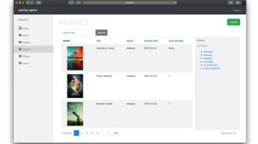
Aiohttp admin is generator for admin interface based on aiohttp
Aiohttp admin Demo site | Demo source code. The aiohttp admin is a library for build admin interface for applications based on the aiohttp. With this library you can ease to generate CRUD views for your data (for data storages which support by aiohttp admin) and flexibly customize representation and access to these. Installation The first step which you need to do it’s installing library pip install aiohttp_admin2
Read more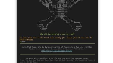
An utility to make reviewing ArXiv papers for your Journal Club easier
jfc is an utility to make reviewing ArXiv papers for your Journal Club easier. Install Consider using pipx. pipx install git+https://github.com/mikeevmm/jfc/ Otherwise, if you are using pip: pip install git+https://github.com/mikeevmm/jfc/ How to Use jfc aggregates unseen articles from the specified timeframe (see the configuration section), and displays them to you in an interactive prompt. From the title, you can choose to read the abstract, and from there you can choose to open the ArXiv PDF. Run jfc to get an […]
Read moreA markdown lexer and parser which gives the programmer atomic control over markdown parsing to html
Version 0.2.0 A markdown lexer and parser which gives the developer atomic control over markdown parsing to html. Atomd first tokenizes the markdown with the lexer. Using the tokenized markdown, parsers for various different markup languages (HTML, XML, etc) are easier to implement, since it more or less becomes a game of find and replace. Install python3 -m pip install atomd Usage Functions in atomd.py called md2 ()combine the lexer and parser to provide an easier calling convention. In the […]
Read more