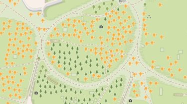
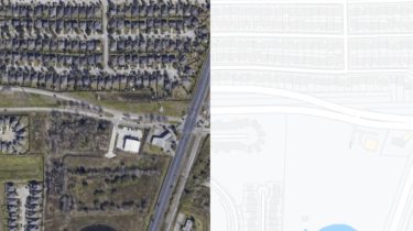
A large dataset of 100k Google Satellite and matching Map images

Larger Google Sat2Map dataset This dataset extends the aerial ⟷ Maps dataset used in pix2pix (Isola et al., CVPR17). The provide script download_sat2maps.py scrapes pairs of matching Maps and Satellite images using the Google Maps API from the 22 most populous cities in the United States. Following pix2pix, the pair of satellite and map images are concatenated side-by-side into one image like below. Occasionally, the satellite or the map image are not provided by the API, or simply not interesting […]

Read more

Riemannian Convex Potential Maps with python

rcpm This repository is by Brandon Amos, Samuel Cohen and Yaron Lipman and contains the JAX source code to reproduce the experiments in our ICML 2021 paper on Riemannian Convex Potential Maps. Modeling distributions on Riemannian manifolds is a crucial component in understanding non-Euclidean data that arises, e.g., in physics and geology. The budding approaches in this space are limited by representational and computational tradeoffs. We propose and study a class of flows that uses convex potentials from Riemannian optimal […]

Read more

Real-time Instance Segmentation with Discriminative Orientation Maps

OrienMask This repository implements the framework OrienMask for real-time instance segmentation. It achieves 34.8 mask AP on COCO test-dev at the speed of 42.7 FPS evaluated with a single RTX 2080Ti. (log) Paper: Real-time Instance Segmentation with Discriminative Orientation Maps Installation Please see INSTALL.md to prepare the environment and dataset. Usage Place the pre-trained backbone (link) and trained model (link) as follows for convenience (otherwise update the corresponding path in configurations): ├── checkpoints │ ├── pretrained │ │ ├──pretrained_darknet53.pth │ […]

Read more

Solving the Traveling Salesman Problem using Self-Organizing Maps with python

som-tsp Solving the Traveling Salesman Problem using Self-Organizing Maps This repository contains an implementation of a Self Organizing Map that can be used to find sub-optimal solutions for the Traveling Salesman Problem. The instances of the problems that the program supports are .tsp files, which is a widespread format in this problem. All the source code can be found in the src directory, while a report and brief presentation slides (in Spanish) can be found in the report folder. To […]

Read more

Blender addons to make the bridge between Blender and geographic data with python

Blender GIS GIS datafile import : Import in Blender most commons GIS data format : Shapefile vector, raster image, geotiff DEM, OpenStreetMap xml. There are a lot of possibilities to create a 3D terrain from geographic data with BlenderGIS. Flowchart Exemple : import vector contour lines, create faces by triangulation and put a topographic raster texture. Grab geodata directly from the web : display dynamics web maps inside Blender 3d view, requests for OpenStreetMap data (buildings, roads …), get true […]

Read more

A 3D Dense mapping backend library of SLAM based on taichi-Lang designed for the aerial swarm

TaichiSLAM This project is a 3D Dense mapping backend library of SLAM based Taichi-Lang, designed for the aerial swarm. Taichi is an efficient domain-specific language (DSL) designed for computer graphics (CG), which can be adopted for high-performance computing on mobile devices. Thanks to the connection between CG and robotics, we can adopt this powerful tool to accelerate the development of robotics algorithms. In this project, I am trying to take advantages of Taichi, including parallel optimization, sparse computing, advanced data […]

Read more

A Python package for geospatial analysis and interactive mapping

leafmap A Python package for geospatial analysis and interactive mapping in a Jupyter environment. leafmap is a Python package for geospatial analysis and interactive mapping in a Jupyter environment. It is a spin-off project of the geemap Python package, which was designed specifically to work with Google Earth Engine (GEE). However, not everyone in the geospatial community has a GEE account. leafmap is designed to fill this gap for non-GEE users. It enables users to perform advanced geospatial analysis and […]

Read more

A simple renderer for OpenStreetMap with python

Roentgen The idea behind Röntgen project is to have a possibility to display any map feature represented by OpenStreetMap data tags by means of colors, shapes, and icons. Röntgen is primarily created for OpenStreetMap contributors. Suppose, you spent time adding colors for building walls, benches and shelters for bus stops but they are not represented on the standard tile layer. Röntgen helps to display all changes you made. Nevertheless, Röntgen map generator can generate precise but messy maps for OSM […]

Read more

A python package that extends Google Earth Engine

eemont Google Earth Engine is a cloud-based service for geospatial processing of vector and raster data. The Earth Engine platform has a JavaScript and a Python API with different methods to process geospatial objects. Google Earth Engine also provides a HUGE PETABYTE-SCALE CATALOG of raster and vector data that users can process online (e.g. Landsat Missions Image Collections, Sentinel Missions Image Collections, MODIS Products Image Collections, World Database of Protected Areas, etc.). The eemont package extends the Google Earth Engine […]

Read more
1 2