A Google Maps Tool Collects What’s Available For A User-specified Region In The Form Of A GIF
google-maps-at-88-mph
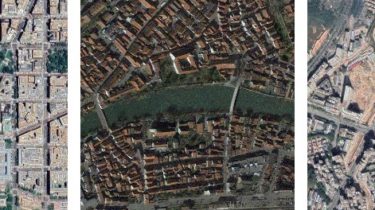
The folks maintaining Google Maps regularly update the satellite imagery it serves its users, but outdated versions of the imagery are kept around in for a year or two. This Python-based tool automatically crawls its way through these versions, figuring out which provide unique imagery and downloading it for a user-defined (that’s you! you get to define things!) area, eventually assembling it in the form of a GIF.
This weekend project is based on ærialbot, a previous weekend project of mine.
Scroll down to learn how to set it up on your machine, or stay up here for some examples.
There’s usually two or three different views of any given area available in the “version history”, which can yield neat 3D effects (the attributes contain the