A public available dataset for road boundary detection in aerial images
Topo-boundary
This is the official github repo of paper Topo-boundary: A Benchmark Dataset on Topological Road-boundary Detection Using Aerial Images for Autonomous Driving.
Project page.
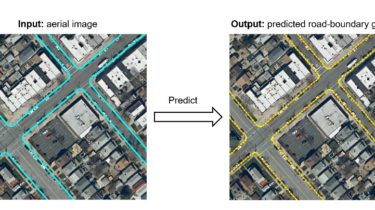
Topo-boundary is a publicly available benchmark dataset for topological road-boundary detection in aerial images. With an aerial image as the input, the evaluated method should predict the topological structure of road boundaries in the form of a graph.
This dataset is based on NYC Planimetric Database. Topo-boundary consists of 25,297 4-channel aerial images, and each aerial image has eight labels for different deep-learning tasks. More details about the dataset structure can be found in our paper. Follow the steps in the ./dataset to prepare the dataset.
We also provide the implementation code (including training and inference) based on PyTorch of 9 methods. Go to