Django Jet ile Nasıl Daha iyi Django Admin Sayfası Tasarlanır ?
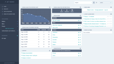
Django Admin Sayfası bir database yönetim sayfasıdır. Model classlarımızda oluşturduğumuz objeler ORM ile db’ye aktarılır. Django’nun admin sayfası birçok kişiye göre sade kalmaktadır, gerçek bir admin dashboard’ına nasıl benzetebiliriz hangi kütüphaneleri kullanmalıyız bu yazımda bu konudan bahsedeceğim. Örnek Django Jet Uygulaması:
Read more