Package for uncertainty analysis in Python
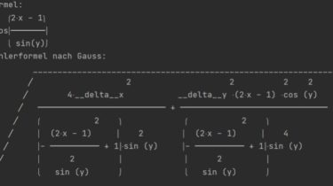
Currently in rewriting phase. Package for uncertainty analysis in Python.It was developed while I was doing my Bachelor in physics.The functionality is based on the lab courses. Warnings The function exec is used within some functionalities.This can cause harm if exploited. General introduction The main classes of the package are Data, Table and Formula.The package holds functionality for: Error/Uncertainty propagation in equations Create tables and calculate different types of averages including arithmetic, geometric, modus, … Normal and simplified gauss propagation […]
Read more